
 On 10/12/1999 I went for the 5th time to the land of the pharaohs. First we wanted to look at pyramids for one week, and then
look at some fishes for another one. With me was my old friens and business partner Frank Stachowiak (abbr. FS), and
"Pyramid-Rainer" Lorenz. Later two other frieds should join us, Dirk von Heimburg and Carsten Decking. Our travel plan was quite
tight and risky. We only hat a hotel for the first days, all after that, hotel and travel to Hurghada and back, had to be booked
on the spot. No problem, we thought, who travels to Egypt at that time of te year? Well, Frank Dörnenburg and planning...
On 10/12/1999 I went for the 5th time to the land of the pharaohs. First we wanted to look at pyramids for one week, and then
look at some fishes for another one. With me was my old friens and business partner Frank Stachowiak (abbr. FS), and
"Pyramid-Rainer" Lorenz. Later two other frieds should join us, Dirk von Heimburg and Carsten Decking. Our travel plan was quite
tight and risky. We only hat a hotel for the first days, all after that, hotel and travel to Hurghada and back, had to be booked
on the spot. No problem, we thought, who travels to Egypt at that time of te year? Well, Frank Dörnenburg and planning...
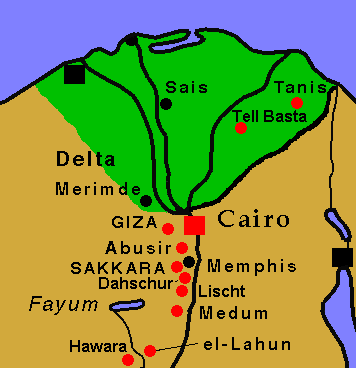
Our first week went to the red marked places on the map: Bubastis (Tell Basta) and Tanis in the Nile delta, Giza, Abusir,
Dahschur, Saqqara and Lischt near Cairo, and Meidum and the pyramids of Lahun and Hawara in the Fayum oasis.
FS develloped a really original theory about the purpose of the pyramids: They were highway markers! On the way south they are so regularly spaced along the Saqqara highway, that almost the time one is in the field of view, and one can calculate the time for reaching Cairo: "Oh, Lischt, about 3/4 of an hour - ah, Abusir, only a few minutes now" :-)
Rainer had planned the first days from home and hat a tight schedule, how long we had to stay where to see what. Unfortunately, we had to discard the plan on the first day, because we saw everywhere more than we anticipated and had to spend much more time as calculated. So from the second day on we only chose a primary target and then looked what happened.
 Pyramids 1999
 Arrival

