
In addition to the various number mysteries to be found in the pyramid itself, the building place should hide some secrets, too. But as in the examples with Pythagoras, many of these "secrets" are empty phrases. Most of them can be proven wrong with a good map and again the greatest mystery is, how this "evidence" could survive so long.
Lets start with an easy example:
"The 30th parallel of latitude north passes right through the center of the great pyramid. And this is a miracle, because exactly on this location the distance to the center of the earth equals the distance to the north pole."
This can be found in books of several authors. But you need only a topographic map of Cairo to see, that the 30th parallel runs a good part north of the great pyramid. In fact, it doesn't even touch the plateau the three Giza-pyramids are built on.
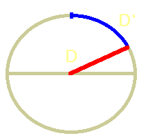 The "even distance"-proposition is even wrong in two ways. The distance between pyramid and the center of the earth (D) is, no wonder, a straight line right through Earth. But the distance to the poles is for us little earth worms the bow segment on the surface of the Earth (D'). And this distance is much bigger than the straight line to the center. To fulfill this proposition, the pyramid had to be built 400 km to the north - right on the bottom of the Mediterranean.
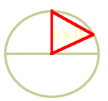 But there is another way to look at this mystery: With a perfect sphere, the direct distances between the 30th parallel and the pole, pole and the center and the center and the 30th parallel are the same. Or, in other words, center, pole and pyramid would be on the edges of a triangle with three equally long sides.
Another evergreen says:
"The great pyramid lies on the apex of the Nile delta. The center line goes right through the middle of it, and the diagonals created by the pyramid are enclosing the whole delta perfectly."
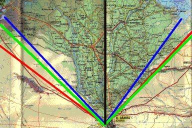 But you only need a precise map to see, that this is wrong, too. But let us first discuss, what the "Nile delta" really is. One definition would be, that the delta, seen from the pyramid, encloses the easternmost and westernmost extensions of all the land irrigated by all small arms of the branching river, and the easternmost and westernmost extensions of all branches of the Nile (red). Another definition would be the easternmost and westernmost mouth of the Nile (blue).
A quick look on a map shows: The pyramid is not located in the apex of the delta, it stands asymmetrically to it, It must be about 20 kilometers to the East to fulfill the condition. Another thing: The greatest extension of the rivers opens wider than 90 degrees, whereas the "mouth delta" opens with an angle much less than 90 degrees. The lines created by the diagonals of the pyramid (green) are lying somewhere in the middle between on the western side, and are opening wider on the eastern side. So they lie somewhere in the middle around it, and are therefore no signs at all.
Oh, by the way: There are other pyramids fitting much better. The Nile turns eastwards south of Giza, so the pyramids further south, like in el-Aryan and Abusir are enclosing the delta much better than the mysterious "great one" :-)
Let's come to the famous "center of the landmasses" the great pyramid should be built at.
"The parallel of longitude passing through the great pyramid is the longest possible parallel passing over ground at all. The parallel of latitude passing through the center of the pyramid is the longest possible over land, too. So the pyramid is located right in the gravity center of all land masses on Earth."
 To demonstrate this, you will be shown maps like the one on the left. But again you only need a map and some time to see that this is wrong, too. The longest possible parallel of longitude runs about 250 kilometers west of Giza, right through the Libyan desert. It runs more than 2000 kilometers longer over land than the one through Giza.
 Also, the longest parallel of latitude over land goes not through Giza. At 50 deg. north I found one running more than 16000 kilometers over land. Compared with the 14000 km of the one through Giza, it is again 2000 kilometers longer. And if I construct the "gravity center of the continents" after the definition given above, the true center must be in the Ukraine, some kilometers west from Kiev. This, too, can be checked with a good map!
The last example I want to deal with on these pages (in my book you will find lots more) shows the ignorance with which some so called "popular science" authors are working. So I read in the book of a famous Swiss author, that "a diagonal drawn on a map which goes through the middle of the great pyramid with an angle of 45 degrees is the longest possible way over land on the Earth at all"
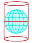 But even Swiss authors should realize, that our Earth isn't flat. Yes, believe me, its a Sphere! And it is a well known fact that it is impossible to flatten a sphere to two dimensions without loss. The only thing we can do to get flat maps is to make projections. To do this we could build a globe of wire and placing a strong lamp in the middle. Then we could for example place a cylinder of transparent paper around it and copy the shadows of the continent boundaries. Doing this, we get maps in the famous Mercator-projection. But these maps don't show the real proportions, the equator regions are on these maps as wide as the polar regions!
Any projection shows angles and distances in another way, so the whole 45 degree-game works only with one specific projection! And it is absurd to think that space aliens thousands of years ago knew what projections are favorites in our times.
The only way to deal with this proposition is, to measure the distance on the round earth - or on a globe. When you draw a full circle around Earth, going in a 45 deg. angle through Giza, you will find out that this runs only about 12000 kilometers over land. Even the parallel running through Kiev is with 16000 kilometers much longer, so this famous mystery is plain (or spherical ;-) ) wrong, too.


 Pyramid mysteries