
Bauval claims that there are more correlations than the failed brightness/height-one from the last side. In fact the picture of the pyramids on the ground should not be similar to the sky, but it should be a direct representation, a mirror image of the sky above.[1]]
|
Shortly after the release of his book a war started on several discussion boards. The question being debated: What is a "picture of the sky"? In my opinion (which is shared by several Bauval-sceptics) we have to differentiate between a picture and a map of the sky. The sky is above our heads. If I take a piece of paper and mark the position of the constellations above and put this picture before me, I have a map of the sky. I would get a picture of the sky if I drew the stars in positions where they would be projected down from the sky. Such an image would be a mirror image, like the picture of the stars seen in a lake or a large river.
In his publications and debates Bauval regularly emphasizes that he means a picture and not a map, so we know what we are looking for.
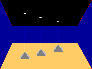
It is simple to test this thesis, we do not need any complicated calculations. Just travel to Giza in winter (as I did in December 1997), go to Giza when the sun sets and wait for the stars to come out, A bright moon illuminated the pyramids, running ghost-like from northeast to southwest, and Orion's belt, running above - from southeast to northwest... Stop, something must be wrong here!
|
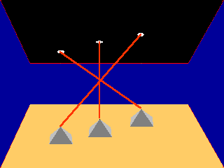
Bauval made a big mistake in his theory - the whole pyramid arrangement is not a picture but a map of the sky. It's flipped around 180°, therefore Orion's belt runs across the line of the pyramids! You have to turn around either the sky or the pyramids to get Bauval's proposed picture!
In Bauval's eyes this is nitpicking. North, south, as if it matters. So you have to turn around, what's the big deal? Well, the big deal is, that you cannot see Orion if you "turn around". But why does Bauval's idea look so good in his book? Well, that's a matter of perspective :-)
Most ancient cultures initially had a similar view of the earth: A flat, round thing, surrounded by water and covered by a gigantic hemisphere. The stars seemed to be attached to this sphere which seemed to rotate around the Earth. In the earliest times they tried to capture the happenings in the sky by painting pictures of what they thought happened there and constellations onto the ceilings of tombs or on other domed rooms - the earliest forms of planetariums which have the same domed ceilings today.
Because of this virtual dome the stars are not flat projections, like on a billboard, they seem to bend "inwards". Let's take a look at the night sky in winter, from a place where you can see the southern horizon. A fantastic view, thousands of twinkling stars. The southernmost stars seem to be far ahead, not just "deep down", whereas the higher stars seem to be nearer and not just higher. The higher a star the more you have to twist your neck and several stars are right "above" you. And lots of stars are behind you. This is a view which cannot be captured by sketches in a book, but this is exactly the reason for Bauval's mistake. A band of stars arching from the north to the south would be an unimpressive vertical line on the map - but in reality it would be a glorious bow reaching over the head of the viewer.
Now the next step. Take a sheet of paper and a pen. Draw three dots in a diagonal running from top left to bottom right. Hold up the "map" and compare it with Orion's belt. Looks good, doesn't it? Now hold the paper flat in front of you and compare the dots with Orion NOW. Try to imagine the dots as buildings. Doesn't look quite so good, does it? Strange, something is missing. Now flip the paper around (turn the front to the back) and mark on this side the exact positions of the dots on the other side. Compare the picture now with Orion: this looks right, you will agree. Hold the paper up to the sky: Funny, now the stars run across the line of Orion. That is the whole secret.
Of course you can also do this experiment without a real Orion. Place three similar items, like teacups, on a sheet of paper. Put them into a diagonal running from top-left to bottom-right. Place another piece of paper over the items and mark their positions with a circle. Then place the paper behind your "teacup-Giza". You see three pharaonic teacups on the desk, and three stellar circles running in a diagonal similar to that of the teacups. Now get the paper and hold it over your head. Now compare the cups and your Orion - Duh! Not a match any more. Hold it deeper over the cups with an angle of 45° - as misaligned as possible. Only if you hold the paper almost vertical and low behind the cups you get the similarity Bauval talks of.
Bauval's main problem is his fixation with a "picture of the sky" A symbolic map - fine with me. But he needs the picture to get his date. You can't get a precise date out of a symbolic map, so all has to be a correct picture of the sky. I asked him twice and his response was: "It's a picture, not a map".
But this "picture" analogy is so visibly wrong that a friend of mine who helped me in Egypt in1997 mumbled "I hope they had a guarantee on this and got their money back..." :-)
In 1999 the BBC aired a two part documentary ("a scandal" in the eyes of Bauval and Hancock) which covered this problem, too (transcripts here). In it astronomer Dr. Ed Krupp accused Bauval of not making it clear in his book that the associated pictures of Giza and of Orion's belt do not have the same orientation: Orion was turned upside down in the book. Bauval got really angry and told in an "open letter" you can find on Graham Hancock's site, that he had never had suppressed this information, it's somewhere in his book (eg. on plate 2 which shows a map) and if the reader doesn't get the connection, it's not Bauval's problem. His friend and co-author of several later books, Graham Hancock, gave a further answer, which was cut-out by the BBC was:
"Ed Krupp's argument that the pyramids are somehow upside down in relation to the patterns of the stars in the sky, to my mind, is a very pedantic and nit-picking and ungenerous attitude. I think that what we're proposing -- that the Ancient Egyptians were making a pleasing, symbolic resemblance to what they saw in the sky on the ground -- is a very reasonable argument."
Pedantic? Symbolic resemblance? Well, what has happened to the "precise map" here???
Pedantry and nitpicking - Bauval's fans picked up these words with astonishing speed. Criticism on such minor points like how a picture has to look are nothing more than nitpicking. Well, all these Anti-nits should travel to Giza in winter to see with their own eyes just how nitpicking this is...
Again, this idea of Bauval clearly is Wrong!
Besides the "core-OCT" there is, as I mentioned in the introduction, something called "the wider picture" which includes the pyramids in Abu Roash, el-Aryan, Abusir and Dahsur. In point (5) of the thesis-page it says:
"Carefully aligning the Giza group pyramids with the stars of Orion's Belt, I saw that the pyramid of Nebka at Abu Ruwash corresponded with the star Saiph or Orion's 'left foot' and that at Zawyat al-Aryan represented Bellatrix in his ''right shoulder'".
|  |
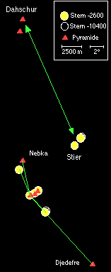
Hmm, Nebka und Abu Roasch? That's plain wrong becaus Abu Rowasch was the building location of Djedefre, Khufu's elder son. Funny: I found this mistake in several books. Again a sign of uncritical copying :-)
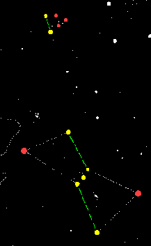
Apart from this annoying error the idea looks good, especially when accompanied by drawings like the one on the left. Bauval shows with similar sketches how well the stars and pyramids match (I marked the stars matched by pyramids yellow, stars without known pyramids in red).
This point is a central argument for Bauval's thesis, so I expected some hard facts to support these sketches. Tables with distances and angles for example, like he does with his other evidence. Or at least some scaled maps. But nothing like this can be found in his book. No proof, just the simple proposition "the match is (somewhere out) there". Egyptologists wondered about this shortly after the publication of Bauval's book and asked for supporting values, but nothing has come yet. So I found some maps and measured myself.
To judge how well the Egyptians could have built a stellar constellation on the ground we first have to see how precisely they could draw a map. The Egyptians weren't master astronomers and they had no hi-tech measuring gear. But that is not necessary. To reproduce a constellation on a piece of paper you only need your fingers!!! That is because you don't need to make a precise map of the whole sky. You only need some stars around a given fixed point, for example the lower left belt star of Orion.
Your thumb at the end of your outstretched arm covers about 2° of the sky, or 4 full moon diameters. Your small finger covers 1°, a palm width (4 fingers) 8°, a hand 20°. If you start measuring Orion from al-Nitak, the upper left star is one palm and a small finger higher and one thumb and a small finger more to the left. The lower star is one palm lower and a small finger width further to the left. Both stars have a distance of two palms and a small finger from each other. In this way you can measure the whole constellation in just a few minutes. To build a pyramid you would have used better measuring gear, a cubit rod with moveable sliders for example, or an accurate comb. With such simple devices it is possible to measure out constellations to at least 1/3rd full moon diameter or 10' (minutes of angle) accuracy within a few minutes.
Let's now bring the sky down to Earth. After turning the plan dutifully around (to get an image and not a map) the Architect has to make the layout on the ground. It's best to start with the most significant and densest cluster in Giza. The architect would have started with a scale on the lines of "one finger in the sky shall be X Chet on the ground" (1 Chet = 100 cubits). And he would have used the same scale for all other distances and buildings.
Giza is the central point because you can see all the included pyramids from there. If, of course, you have good weather and not too much pollution. To position the other pyramids in the landscape they would send out measuring teams with long measuring bands or rods in the designated directions. The land is mostly flat, especially between Sakkara and Dahshur, so the teams would have met with few problems. Only Abu Roasch could have been a problem with measuring the distance because of the high, nearly vertical cliff you have to climb. Errors in distance would be expected biggest there.
How big would the overall error have been? 1 cubit per Chet? Hardly, maybe a palm per chet. The distances for such an important project would have been carefully measured several times. Hills could have a larger influence as the difference between a "straight line" and the "up hill and down dale" distances had to be corrected for. So I would assume an error of less than 10% of the distance, maybe even less than 5%. The angles would also have to be corrected. So after the distance was fixed by the first group they would build markers; a large smoking fire at each point. The architect could measure them from Giza and send messengers to say "2 chet westwards", etc. With such methods you could easily achieve an accuracy of one degree or less (that's the width of a small finger on the horizon). So even with simple techniques quite a good accuracy would have been possible.
Let us now compare the positions of the pyramids to these ideas. I used the following steps: First I calculated the differences of the stars Right ascension (x) and Declination (y) and calculated the effects of the star motion. Because Bauval believes in a planing era of 10500 BCE I calculated the positions for 10500 BCE and 2600 BCE. The measurements were again taken from Yale Catalogue of bright stars. Calculated to minutes, the distances are:
| Star | x(-2600) | y(-2600) | x(-10500) | y(-10500) |
|---|---|---|---|---|
| Alpha ORI | -218 | +562 | -221 | +564 |
| Beta ORI | +394 | -382 | +394 | -382 |
| Gamma ORI | +235 | +497 | +237 | +496 |
| Delta ORI | +132 | + 97 | +132 | + 98 |
| Epsilon ORI | + 69 | + 45 | + 69 | + 46 |
| Kappa ORI | -105 | -383 | -105 | +461 |
| Alpha TAU | +968 | +1108 | +959 | +1069 |
| Epsilon TAU | +1089 | +1247 | +1089 | +1248 |
As you can see, the motion of the stars is negligible.
For the second step I identified the pyramid positions from several maps (my main map was the pilot map TCP H-5A) and calculated the distances (Dx, Dy). I had to rotate these 14.29° around Khufu's pyramid to get the best angular correlation between the belt stars and Giza (Dx', Dy'). These values can be found in this table:
| Pyramid | Dx' | Dy' |
|---|---|---|
| Kaphre | 395 m | 258 m |
| Mykerinos | 756 m | 560 m |
| Djedefre | 6036 m | -6284 m |
| Nebka | 360 m | 4655 m |
| Red Pyramid | -1413 m | 20380 m |
| Bent Pyramid | -1260 m | 21785 m |
The last step is to get the proper scale for minutes -> metre. Because Orion's belt is the centre for all assumptions I decided to take a scale which fits the Giza pyramids and the belt stars in the best possible way. The distance between the centres of the pyramids of Khufu and Menkaure is 942 metres, the distance between the corresponding stars was between 2.73° and 2.74° in the years 2600 BCE and 10500 BCE. This means that 1° in the sky is a distance between 343.8 m and 345 m on the ground. Because of the negligible star movements (even Aldebaran moved only a few dozen metres) I dropped the 10500BCE-value in the following table. Here are the results:
| |||||||||||||||||||||||||||||||||||
The circles on the map are where the pyramid had to be considered as a hit. Unfortunately the really bad angular errors don't show very well, but you can calculate them from the data. As you can see the Giza pyramids are inside their tolerances. But all the other pyramids are not even near their proposed positions. Djedefre's pyramid is 4100 metres too far away - three times the distance it should be. You remember that I expected problems there because the pyramid is located on a high cliff. But with the factor between sky and ground built into the Giza plateau, the pyramid would have to be nowhere near Abu Rowasch.
To make things worse, its angular error is about 5°, 10 full moon diameter or nearly 3 fingers on the horizon. Nebka's is 2000 metres too far away. But its angular error is 30 (THIRTY)°. The biggest errors can be found at Dahshur. The angular error between Aldebaran and the red pyramid is more than 40° or 2 spread hands on the horizon. The difference from its target is more than 12 kilometres. There is no match, not even a slight similarity. I tried other values for angle and distance, even an average value as suggested in 1995 by some of Bauval's supporters. The only result was that the match at Giza was lost. No, this doesn't work. Ah, by the way: to get a picture you have of course to turn the whole picture around. Bauval also associates pyramids far down in the south with stars high up in the north...
By the way: with this data we have eliminated another points from our initial list of mysteries:
(6) "With 'Bellatrix' located south-east of Giza it was not difficult to see how the three or four little stars forming Orion's 'head' could fit the three or four (...) little pyramids at Abusir, a kilometre or so south-east of Zawyat Al Aryan."
Since el-Aryan is already kilometres off its target, those "3 or 4 " which are in fact "5 or 7" small pyramids are even farther off.
No problem, Bauval declared the once precise map to be only symbolic, too:
"Chadwick's approach to this problem, however, typifies the complication and distortion that arises when religious art and architecture is explained by scientific (i.e. astronomy) methods. The scientist totally ignores and misunderstands the magical properties of such art; and foolishly thinks of it as some scientific problem which he or she can rationalise."
Ommmmm - no doubt, this idea is wrong again!
| Remarks: | |
| [1] | That is the basic point of the thesis, although not explicitely claimend, it is supported by a lot of skethces in book and documentation, like Bauval/Gilbert, Fig. 18, p. 225 |
| [2] | ibd. p. 131 |
 Light of the Pharaohs The Manna Machine
 The Orion-Pyramids Pyramid mysteries Worldwide Mysteries Discussion blogs